
Newly completed flood-risk mapping for Middle Rock Creek and Lower Rock Creek watersheds now available
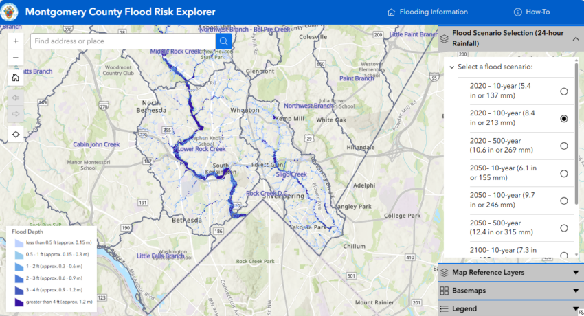
Montgomery County Executive Marc Elrich has announced the expansion of the County’s interactive flood risk map, the Flood Risk Explorer, adding two additional watersheds as the Atlantic Hurricane season is now underway. The Flood Risk Explorer now includes newly completed flood‑risk mapping for the Middle Rock Creek and Lower Rock Creek watersheds. These areas add to the Sligo Creek watershed, which was the first to be mapped when the tool launched in December.
The Flood Risk Explorer highlights areas in each watershed that face elevated flood risks during extreme rainstorms under current climate conditions and projected future scenarios. It is available on the County’s Flooding webpage.
“Flooding is becoming more frequent and more dangerous as we experience stronger storms and heavier rainfall tied to climate change,” said County Executive Elrich. “Expanding the Flood Risk Explorer gives residents better information about the risks in their neighborhoods so they can take steps now to prepare, protect their property, and stay safe during severe weather events. The more information residents have before a storm arrives, the better prepared our community will be.”
Advertisement
The Flood Risk Explorer helps residents understand the relative likelihood of flooding where they live, work, and commute. All County residents can benefit from resources available on the County’s Flooding webpage, which outlines simple steps to prepare:
- Know your flood risk.
- Sign up for Alert Montgomery.
- Plan and protect your home or business.
- Consider flood insurance.
- Be weather aware.
The Flood Risk Explorer is part of the County’s Comprehensive Flood Management Plan, a multi‑agency initiative to prevent, prepare for, respond to, and recover from flooding. Watch a short how-to video that explains the Flood Risk Explorer.

The County uses a range of tools to address flooding and flood emergencies:
- Forty flood sensors are installed in high‑risk areas, monitored by the Office of Emergency Management and Homeland Security. These sensors notify public safety agencies of rising water levels so they can proactively close roads.
- The County’s Department of Transportation operates the Storm Operation Center, which activates ahead of storms to position highway crews, monitor conditions, and respond quickly to protect public safety.
- Residents should report flooding to MC 311, or to the non‑emergency police line at 301‑279‑8000 after hours. Since many flooded roads do not have sensors, the public is strongly reminded: Turn around, don’t drown. Never drive through flooded roads.
Flooding is the most frequent severe‑weather event and the costliest type of natural disaster nationwide. According to the Federal Emergency Management Agency, 25% of flood insurance claims come from moderate‑to‑low‑risk areas like Montgomery County, and just one inch of water can cause up to $25,000 in damage.
Advertisement
Visit the County’s Flooding webpage for more information and subscribe to Alert Montgomery to receive emergency notifications directly via text.
# # #
Read the original article at mcdep